Capitol Reef National Park is located in... Read More
Capitol Reef National Park is located in... Read More
Capitol Reef National Park is located in... Read More
Capitol Reef National Park is located in... Read More
Capitol Reef National Park offers a spectacular lesson in geology, presenting a vast, exposed sequence of sedimentary rock layers that document over 250 million years of Earth's history. The park’s defining feature, the Waterpocket Fold, acts like a massive cross-section, tilting and exposing rock formations that tell a dramatic story of shifting environments. Geologists use the science of stratigraphy, the study of rock layers, to "read" this history, moving from the oldest layers at the bottom to the youngest at the top. This vertical journey reveals ancient oceans, vast swamps, muddy riverbeds, and towering Saharan-like deserts, all preserved in stone.
The lowest and oldest visible rocks tell a story of marine environments. Formations like the Kaibab Limestone were laid down in the shallow seas of the Permian period, approximately 270 million years ago, indicating that this area was once submerged beneath an ocean teeming with life. As the seas retreated and advanced, the environment changed to massive floodplains and swamps, documented by formations such as the colorful Moenkopi and Chinle Formations. These layers are rich in mudstone and siltstone, often containing fossils of ancient reptiles and petrified wood, demonstrating a transition to a vast, low-lying continental setting crisscrossed by rivers that flowed across a massive inland basin.
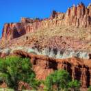
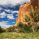
The most recognizable and dominant rock layers in Capitol Reef speak of an incredibly arid period. The iconic white cliffs and domes, including the park’s namesake Capitol Dome, are composed of the monumental Navajo Sandstone. This formation, reaching thicknesses of over 2,000 feet in some areas, represents the remnants of a super-dune field, one of the largest on the planet, resembling a vast ancient Sahara Desert. Within the Navajo Sandstone, preserved cross-bedding marks the internal structures of these enormous, petrified sand dunes. Overlaying the Navajo is the Entrada Sandstone, which formed under different coastal conditions, often creating the remote, castle-like monoliths found in Cathedral Valley.
The sequence continues through the Cretaceous period, marked by layers like the Mancos Shale and Mesaverde Group, which reflect the final, dramatic return of deep seas across the continent, known as the Western Interior Seaway. Finally, the entire sequence was uplifted and tilted by the tectonic forces of the Laramide Orogeny around 70 million years ago, creating the Waterpocket Fold. Today, the work of erosion is dominant, carving canyons and arches into these exposed layers. By tracing the color, texture, and composition of each stratum from the colorful Shinarump Conglomerate to the massive Navajo Sandstone, visitors can see geological time laid bare, allowing them to literally walk through the evidence of continental drift, climate change, and the endless cycling of Earth's surface environments.
Capitol Reef National Park offers a spectacular lesson in geology, presenting a vast, exposed sequence of sedimentary rock layers that document over 250 million years of Earth's history. ...
Read More
Capitol Reef National Park offers a unique blend of geology, history, and outdoor adventure. Its towering sandstone cliffs, hidden canyons, and sprawling orchards create a captivating landscape perfect for exploration on foot. ...
Read More